SeaTrak enables you to plan your route at home, using tidal information to work out the best time to leave. You can then transfer the route to your laptop to use as a real-time navigation system on board your vessel.
SeaTrak is feature-rich, the main functions include:-
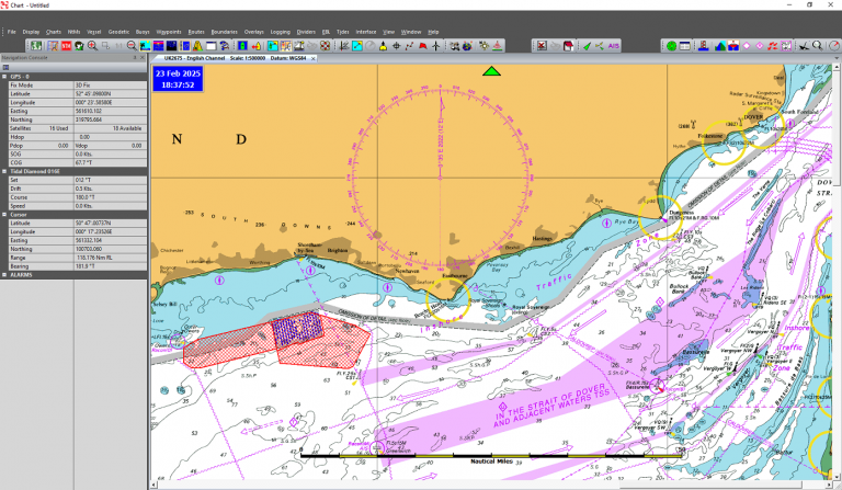
• Display vessel position on chart using GPS
• Overlay AIS targets on the chart
• Logging your position to hard drive and display a vessel snail trail on chart.
• Print positions
• Display projected track
• Dimmable display for use at night
• Overlay boundaries onto chart with option to alarm on entry or exit
• Man overboard
• Vessel fixed mode follow vessel on charts
• Chart fixed mode allows free scrolling around charts
• Full screen mode for complete screen view
of the chart
• Display vessel heading using Course Over Ground or Gyro
• Detailed Satellite information
• Alphanumeric navigation information display
• Set limit for cross track error
• Rolling Road display
• Software and charts can be downloaded from the internet
Positioning
Real-time Navigating can be made easier with the addition of a GPS unit to show your position on an electronic chart. You can also see other vessels by using AIS if you have a receiver or transceiver.
These features are supported in our chartplotters.
• Supports GPS and AIS NMEA 183 input
• Support for Garmin GPS using NMEA 183 or proprietary USB connection
• Ability to use separate GPS and AIS input
• Get vessel position from AIS unit
• Gyro vessel heading
Passage Planning
SeaTrak is ideal for planning your route before you leave, as well as navigating safely once you are under way.
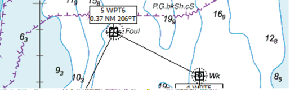
• Tool to measure distances on charts
• Add waypoints using point and click or manually using a specified Latitude and Longitude.
• Editable waypoints from list or selecting on the chart
• Simple point and click route creation
• Detailed route waypoint breakdown
• Ability to reverse route for return journeys
• Print route for a paper backup
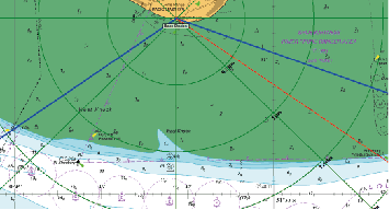
• Detailed route plan with ability to use tides, vessel speed, date and time of departure
• Insufficient vessel speed warning to counteract tidal stream
• Cursor Geographical Position
• Ability to add Notice to Mariners to chart
Tidal Information
Tidal data can help you in planning your route, for example calculating the best time to leave for your destination to prevent sailing against the tide.
• Annual UK Tidal data computed using simple harmonic method
• Tidal ports overlaid on chart
• Tidal curve for each port along with vessel clearance
• Tidal diamonds with real time arrows, set & drift
AIS Monitoring
The application can be configured as an AIS monitoring station.
These features include
• Adjustable Range rings around the base station
• AIS targets can be annotate.
• Colour of different type AIS target.
• Ability to add a casualty to the display
• Predict position of casualty based on tides.
• Log data to be review later.