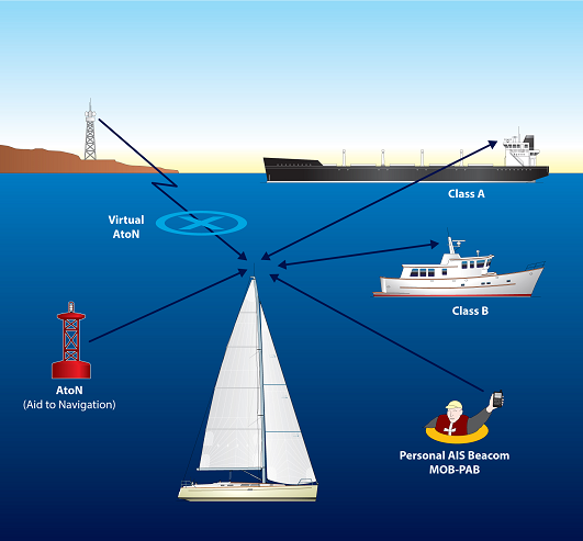
AIS stands for Automatic Idenification of Ships In the context of shipping, it’s a maritime navigation safety communication system that uses VHF radio to transmit information about a vessel to other vessels and shore stations. This information is used to improve collision avoidance, monitor vessel movements, and aid in situational awareness.
What it does:
Transmits Vessel Data:
AIS equipped vessels broadcast information like their name, MMSI (Maritime Mobile Service Identity), location, course, speed, and other relevant data.
Enhances Safety:
This information is used by other vessels to avoid collisions and by shore stations for monitoring and tracking.
Improves Situational Awareness:
AIS provides a clearer picture of the surrounding marine environment, helping mariners make more informed decisions.
Mandated by IMO:
The International Maritime Organization (IMO) mandates the carriage of AIS on large vessels, and many governments also require it on smaller vessels.
How it works:
Transponders:
AIS utilizes transponders, which are devices that automatically transmit information about a vessel.
VHF Radio:
The information is transmitted using Very High Frequency (VHF) radio waves.
GPS Integration:
AIS systems typically integrate with a vessel’s GPS to provide accurate location data.
AIS transceivers on other vessels can receive and process this data, creating a network of information exchange.
Key benefits:
Collision Prevention:
AIS helps vessels avoid collisions by providing real-time information about the positions and movements of other vessels.
Tracking and Monitoring:
AIS allows for the tracking and monitoring of vessel movements, which is useful for search and rescue operations, port authorities, and other stakeholders.
Improved Navigation:
Shore Based Monitoring System
Meridian SeaTrak Application can be configured as a shore based monitoring system
Key Features include:.
- Set up the co-ordinates of a base station and draw rings around the base station to quickly measure the distance from the base station.
- Log all incoming AIS data so this can be played back if an incident occured.
- Set up boundaries and warn if a vessel enters a restricted zone. The system can be configured to send a SMS message to a mobile phone(s)
- Mark the position of a casualty and use tidal stream information predict where the casualty has drifted.
- For a port or harbour ability to set up buoy co-ordinates and display them on the chart.
- Click on any AIS target and view all the known information about the vessel.
- Tidal predictions for the closest tidal port.
- Real tidal predictions using Tidal Diamonds on the chart.
- Interface with any AIS unit with NMEA data Output.